Cornish present and past

We’ve just come back from a very refreshing week in Cornwall, staying at a cottage near Stithians. It was a great location for easy access to both north and south coasts, as well as Land’s End.

The best weather of the week was on the Tuesday when we went to the Lizard Peninsula. We walked from the Point (after a good brekkie for lunch!) to Kynance Cove, which was a wonderfully scenic route.

KynanceCove_6046crlg

Kynance Cove from the Lizard Peninsula

Kynance Cove itself is a sheltered and picturesque bay; unfortunately we didn’t have long there because we needed to get back before sunset.

KynanceCove_6181crlg

Kynance Cove

LizardPeninsula_6118crlg

Looking south from Kynance Cove

On our return, a little person didn’t like being in his carrier, so we took a different approach…

Rich_Joshua_Lizard_0535lg

Walking back to Lizard Point

As it happens, Dad’s family came from Cornwall, and his father was the rector of St.Mawgan-in-Pydar (along the north coast between Newquay and Padstow) in the 1920s. We decided to visit, and found it to be a very attractive village. The old rectory is huge – as the old Vicarage in Shapwick was before the fire around 1910. It’s a good indication of the change in culture of the UK over the last hundred years: although clergy today are very generously housed, there’s no comparison with the enormous houses of one hundred years ago. Either way, it’s all a bit different from the “Son of Man [who] has no place to lay his head”.


A couple of miles coastwards lies Mawgan Porth, a lovely seaside cove.

MawganPorth_6296lg

Mawgan Porth

MawganPorth_PreSunset_6346cr2lg

Mawgan Porth near sunset

We had less fortune, weather-wise, when we went to Crantock, where Jen’s granmother lived and where her family used to go for summer holidays. It was greyer, windier and rainier, and the tide was in… but still good enough for a nice family photo!

JenJoshua_Crantock_2979lg

First family visit to Crantock!

The Teän adventure

One of the highlights of our recent trip to the Scillies was being able to go to Teän, an uninhabited island in the northern part of the group. It’s easily seen from many parts of the Scillies, but isn’t easy to get to in the normal course – unless you’re part of an organised trip, as we were, or have your own boat, which we don’t(!).

The approach to the island is quite impressive as one goes fairly close to a number of other uninhabited islands.

St Helen’s, Round Island lighthouse, and the beginning of Teän

Teän from the sea as we approached it, with Round Island lighthouse visible to the left.

As there is no quay on the island, the landing has to be by boat, by disembarking onto an inflatable dinghy which does the final part of the journey to shore.

Landing on the island via inflatable.

Landing on the beach on Teän.

When we landed, we were surprised by the amount of natural beach debris there was, presumably allowed to accumulate undisturbed by humans and their animals. Jen quickly acquired an impressive handful!

Jen easily acquired some interesting finds from the landing beach.

What was more depressing was the amount of plastic and other waste that had washed onto the island, and reflected the growing problem that’s being recognised locally as well as globally.

Remains of St Theona’s chapel in front and to the right. The wall is more recent.

As well as enjoying being on a deserted island, I was very keen to see the place where St Theona had had her dwelling. She was a Celtic hermit living in about the 8th century. At that time the island was connected to St Martin’s at low tide and would have been a bit less isolated than now; but despite that it still reflects the desire of Celtic mystics to seek out and live in desert places.

Ruins of the chapel and adjacent buildings on Teän.

The other location known for it’s Celtic hermitage is St Helen’s, an island we weren’t able to get to because of the weather, but easily seen to the west of Teän.

St Helen’s and Round Island Lighthouse viewed from Teän.

St Helen’s from Teän

The chapel of St Elidius on St Helen’s – probably the low stone wall just visible above the shoreline left of centre. (Click to enlarge)

After we’d got back to St Mary’s, Jen and I spend some time poring over the photos of St Helen’s to see if we could see the chapel of St Elidius, the 7th century Celtic monk who was a hermit there. By correlating the information on maps with the photos, we’re fairly sure it’s the low stone wall just above the shoreline to the left of centre in the photo to the right.

As Teän has one of the higher hills in the Scillies, it also has one of the best views. The panorama below takes in a 180-degree view from Tresco on the left, past St Helen’s and Round Island (with lighthouse), to White Island and St Martin’s to the right.

Panorama from the Teän main hilltop – from Tresco on the far left to St Martin’s on the far right. Click to enlarge!

View from the top of Teän – St Helen’s and the Round Island lighthouse being the obvious island landmarks.

It was a very memorable trip – and if we get the chance to go again, we’re keen to go to some of the other uninhabited islands.

Indulging the island cravings in the Scillies

Jen and I may be developing a serious case of nesiophilia (according to the dictionary, the inordinate fondness and hungering for islands). Going to the Scillies in the first place feeds the condition – but small islands cut off by the tide offer plenty of opportunities to indulge it still further.

Take, for example, Toll’s Island on the north-east corner of St. Mary’s… we had to cross to it as soon as we saw it, and I soon began speculating about how much fun it would be to camp on it when the tide is in.

Tolls Island, on the north-east side of St . Mary’s

Gugh, the much larger tidal island east of St Agnes, has a similar attraction. Jen wanted to stand in the middle of the bar just as the tide was receding. The only trouble was, the tide didn’t recede evenly, and still washed intermittently across the bar after we thought it had fallen enough, so Jen found herself running to avoid the sea washing over and into her boots! (She wasn’t quite quick enough though!!). A picture from later on in the day shows how much the sea level had fallen in a few hours.

The tide hadn’t cleared the sandbar to Gugh quite as completely as we’d thought.

This really was low tide on the Gugh bar!

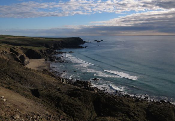
We stayed on St Mary’s for the eight days we were there, and walked most of the coastline on the Saturday. It’s a photogenic island in itself, especially with views across to the other ones.

Round Island Lighthouse from the Town Beach.

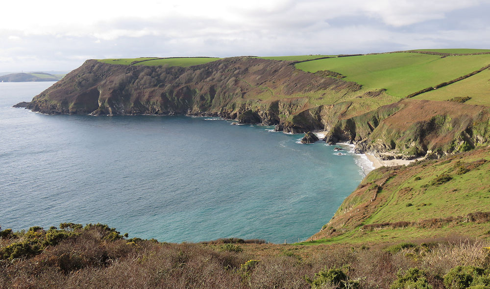
We visited Bryher on one of the days, partly because there was a wildlife walk during  the afternoon. The channel across to Tresco is particularly photogenic – both to the north (from one stretch of moorland to another) and to the much lusher south.

The view across to northern Tresco from Shipman Head Down on Bryher

Looking south to Tresco from Bryher’s Shipman Head Down

My idea of a wildlife walk generally involves birds and mammals, so I was surprised to be enthused about lichens by the excellent leader from the Isles of Scilly Wildlife Trust, Darren Hart. The moorland on Bryher has lots of lichen – which indicates a good air quality. In particular, the golden hair lichen is restricted to only a few places in the south-west of the UK, which are fortunate to have relatively clean air.

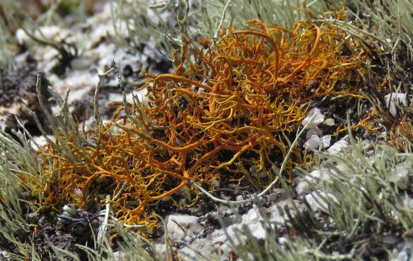
Golden hair lichen on Bryher – rare in the UK, and an indicator of clean air

a native 7-spot ladybird on Bryher

While on this walk I was very excited to see a 7-spot ladybird. I should not be excited about this, but the spread of the invasive Harlequin has meant that seeing a native 7-spot was an event. Six years ago when the species was spreading I heard stories about it cannibalising our native species. I didn’t believe it – until the first one I saw in Cheltenham was, grotesquely, doing exactly that to a native 2-spot. Since then, the only species I have seen has been the Harlequin – until last week when I saw a 7-spot on Bryher.

One island we were keen to visit more thoroughly was St Martin’s, which tends to get overlooked, but has a quiet charm of its own – definitely helped by an outstanding bakery! We decided to explore the eastern and northern coasts. As we approached the daymark in the north-east corner, a group there were about to take a photograph of themselves – so it made far more sense for me to take theirs and for them to return the favour!

Jen and me at the daymark on St Martin’s.

Panorama of the St Martin’s coast from near the daymark in the north-east corner.

Iceland Gull off The Garrison on St Mary’s

The bird-watching during the trip as a whole was less exciting than I was expecting, and I was not anticipating the most notable bird being a gull! I’d seen reports of a couple of juvenile Iceland gulls at Porthloo on St Marys, so saw my first one there – but then found another by chance just off The Garrison at Morning Point. Its whiteness meant that even with my relatively low interest in gulls, I couldn’t really miss it!

Jen: “Do I look fat?”
Me: “Yes. That’s because you’re preggers”

We were keen to take a photo of Jen being preggers, and had several goes at doing so. We eventually realised that a deliberately posed one would look better than one that was meant to look natural while Jen was holding an unnatural pose! We took this one on our walk around the Garrison, shortly after encountering the Iceland Gull.

My attempts at wildlife photography were more limited than I expected but the trip around the Garrison was more fruitful – partly because of an obliging meadow pipit and a couple of showy song thrushes – which are renowned for their approachability compared to the mainland. So I’ll finish with those!

Being stared at by a Meadow pipit

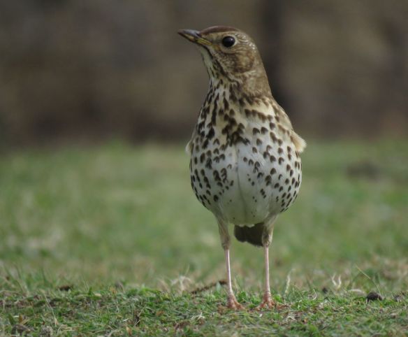
Song thrush on St Mary’s. Getting down to the thrush’s level helped with this photo.

Some Cornish refreshment in Polruan

Jen and I have just come back from a much-needed few days of rest and refreshment in Cornwall. We were able to stay in Polruan thanks to our friends Rico and Lucy, who have a house there.

Not too bad a view from the bedroom window!!

Polruan is a very picturesque large village at the mouth of the river Fowey, directly opposite the town of Fowey, to which it is connected by regular ferry trips throughout the day.

Fowey from Polruan Harbour

We were extremely fortunate with the weather – hardly any rain, and even a cloudless sky on the Friday. We took advantage of this by going on several coastal walks. Two of these were east of Polruan: one to Lantic Bay and the other from there for another couple of miles. The third was from Fowey round to the headland named ‘The Gribbin’, and which gave some stunning views back towards the Fowey river mouth. We also did the ‘Hall Walk’, which is a 4-mile loop around Polruan, Fowey, and the lower parts of the river, and also involves two ferry crossings! Most of these walks we were able to do straight from the front door.

Lantic Bay, a couple of miles east of Polruan

Polruan harbour, viewed from the path going west towards the Gribbin.

On Sunday we went to the church in Fowey, and we were impressed by the warm welcome and the commitment to the faithful teaching of scripture. We met and chatted with a lady called Anne, who then invited us to join her and her husband Dick at the local sailing club for lunch. This was an unexpected and very enjoyable occasion!

Boatyard at Polruan

From the house, we could see a boatyard which was in active operation throughout the working day. One of the people we met at the sailing club happens to be the owner of the boatyard. The orange boat above (and you can tell that I’m really into precise sailing lingo!) is being built from scratch and is nearly complete, while the blue boat, which is from St. Martin’s in the Scillies, is one that they built twenty years ago, and is now being refurbished. Tourism may be the main part of the economy, but there is clearly more to the area than just that.